The Cobourg - Peterborough Railway
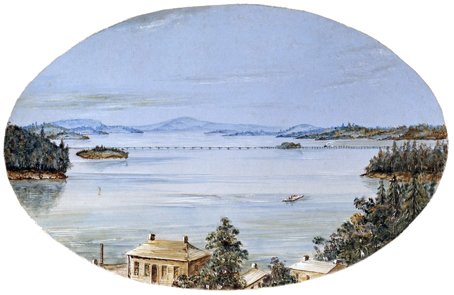
Rendition of the Rice Lake Bridge by Fred J Rowan c. 1860
The Cobourg Peterborough Railway (chartered in 1834), one of the first built in central Ontario, it followed the path of a 17 Kilometre wooden road, known as Plank Road, constructed by the Cobourg and Rice Lake Plank Road and Ferry Company, 1846. The road traveled from Cobourg through Hamilton Township to Rice Lake.
The Cobourg and Peterborough Railway extended their vision beyond Rice Lake to Peterborough. Unfortunately the company suffered throughout its existence from the duplicity of certain of its directors, the unscrupulous
practices of its construction contractor, and a lack of practical organizational and operational experience. Contributing to its woes, the Company undertook a massive civil engineering project, the second largest in North America at the time,
the crossing of Rice Lake on a combination of trestles, 31 Burr-Truss bridges, and a single centre-pivot draw bridge, a complex that extended some 2˝ miles. The ravages of winter ice, and the actions of the owners of the competing P H L and B in dismantling some of the iron stays from the bridge, combined to force the railway to terminate
operations across Rice Lake by 1861. The railway became moribund for half a decade. A group of U.S. investors purchased both the C and P Railway, and the Marmora Iron Mine and created the Cobourg Peterborough and Marmora Railway and Mining Company in 1867. A new rail line was constructed from Trent
Narrows, on the Trent River, north to Blairton and the iron mine there. Ore, brought by rail, from Blairton to Trent Narrows, was dumped by a raised trestle onto barges in the Trent River. A steam boat and barges were contracted to transport the ore on Rice Lake to Harwood, where a steam operated elevator transferred the ore from the barges to ore cars on the
old C and P line. The ore cars were taken by rail to Cobourg harbour and dumped from an elevated trestle, onto harbour land to await transfer to the holds of vessels. These ships then transported the ore to other ports, such as Rochester and Cleveland. While the C P and M R and M Company enjoyed a very modest success initially, the devastating North American economic crisis of 1873
significantly curtailed profits, and the Company’s future. In the 1870's the railway operated sporadically, the C P and M R and M Company became moribund by the early 1880s.
In 1885 a Belleville, Ontario, entrepreneur purchased the C P and M R and M Company, in the Court of Chancery for $30,000. He reorganized the company as the Cobourg Blairton and Marmora Railway and Mining Company. This company suffered from underfunding, a lack of market for iron ore, the depletion of the timber and lumber from the northern forests. The Grand Trunk Railway
absorbed the C B and M R and M Company in 1893.
Today, little exists of the C and P Railway, the remnants of the bridge complex, across Rice Lake were submerged by the Trent Canal system in 1920, and the track to Cobourg’s harbour was removed in the 1980s.
The Cobourg & Peterborough Railway's trestle across Rice Lake had the distinction of being ....
CANADA' S LONGEST RAILWAY BRIDGE
from the Canadian Railroad historical Association news report no.
94
An Account by C.W. Kenneth Heard.
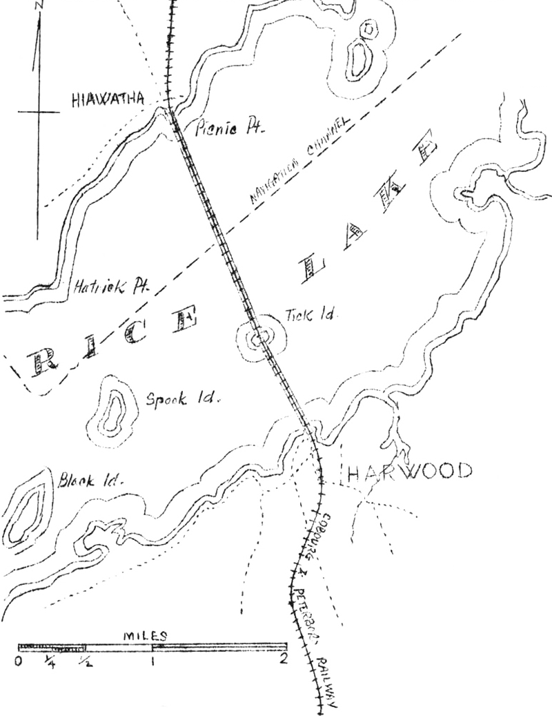
T HE MAJOR OBSTACLE in the route of the Cobourg & Peterborough Railway was Rice Lake, which lay athwart the path of this pioneer line; the C. & P. R. was incorporated in 1852, under the laws of the Province of Canada (16 Vic. Cap.40) to build between the towns mentioned in its title. Projected in 1852, the railway chose a path which involved a crossing of Rice Lake, the only appreciable body of water in the vicinity. The lake, about fifteen miles inland from Cobourg, on the shore of Lake Ontario, is about 18 miles long and less than three miles wide, at its widest point.
The reasons for deciding to build across Rice Lake are obscure. It has been surmised, with little documentary substantiation, that inasmuch as the Peterborough & Port Hope Railway was being projected at the same time, it would be better, in the interests of traffic, to build the Cobourg & Peterborough line sufficiently removed from the former so that each line would open up a different section of the country for lumber development. Moreover, in order to avoid the grades which faced the Port Hope road, on its way out of Port Hope, it was considered advisable to build the line sufficiently east so as to avoid the steepest part of the height of land between Lake Ontario and the Trent River watershed. It was felt that the added expense of a bridge across Rice Lake would be more than compensated for by lower operating costs otoer a more easily graded line. As it turned out, however, the costs of the bridge (which, incidentally, was finally built across the widest part of the lake) exceeded all estimates and the Port Hope road was able to capture the lion's share of the Peterborough-Lake Ontario traffic all year 'round.
Thus, with two strikes against it at the start, the railway commenced construction. The contractor was none other than Samuel Zimmerman, who had held many contracts for railway building in Ontario, and who was to meet his death in the collapse of the Desjardins Canal bridge which, ironically enough, had been built by himself. While the railway was opened for traffic in May, 1854, Zimmerman would not hand it over, claiming that the line was not yet finished. Consequently, in 1855, when the stipulated three years were up, the line was still technically unfinished.2 The contractor would give no substantial reason for his delay, nor would he make any concessions for improperly constructing the bridge over Rice Lake. The original plan called for a rock and gravel causeway held in place by piles, with a drawspan in the middle. Zimmerman's engineers, however, had underestimated the depth of Rice Lake and consequently substituted for the original causeway, a trestle and bridge. Further, in an effort to avoid heavy (and costly) earthworks, Zimmerman had built the line over the height-of-land between Cobourg and Harwood With a ruling gradient of one in thirty {3,3%) in both directions, thus reducing considerably the effective capacity of the locomotives. Zimmerman, notwithstanding the reprehensible construction, refused to turn the assets over to the railway until he had been paid for "extras". The Company thus hid not get possession of the nominally-completed road until late in 1855.
The bridge, referred to by a prominent Canadian engineer, T. C. Clarke, C.
E., as "perhaps the longest railway bridge on this continent, and one of the largest in the
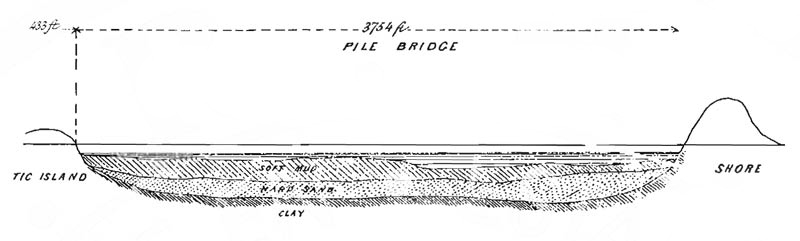
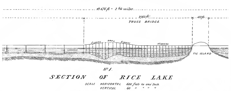
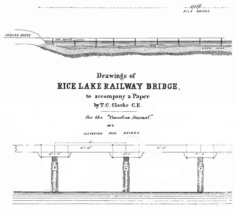
world"3 was two-and-six-tenths of a mile in length, over the widest part of Rice Lake. The railway crossed from Harwood, on the south shore, to Tic Island by a pile bridge 3,754 feet in length. On Tic Island it curved a little, the deflection being
2Ľ°. From there to the north side of the main channel, a distance of 2,760 feet, there was a succession of wooden cribs 10x20' in size, sunk on eighty-foot centres and filled with stone. These served to support thirty-three 80-foot Burr Truss spans.
In the channel, there was a "pivot draw on a turntable1' (swing bridge), 120' long, and supported by a pier 20x40' in size, giving two openings of fifty feet each for navigation. In order to allow for a clearance of twelve feet between high water and the bottom of the swing span, allowance thereby being given to permit the passage of low barges, etc., without swinging the bridge, the eight spans on either side of the
swing span were inclined at a gradient of about 1 in 70 (1.43%). Obviously, such a gradient on a structure of this type, introducing, as it did, a hump into what was to all intents and purposes a wooden trestle two-and-a-half miles long, left something to be desired from an engineering point of view. Starting at Tic Island, the first seventeen Burr Truss spans were level, then followed the eight spans inclined upward, the swing span, then the eight spans inclined downward. At this point, the end of the truss bridge, another pile trestle 6,728 feet in length, similar to that extending out from the south shore, connected the truss with the north shore. This north side trestle, however, was strengthened every five hundred feet by a crib 10x20' in size, loaded with stones.
The bottom of Rice Lake is black mud in a semi-liquid state, and as such afforded no support to piles. Under the mud, there was a stratum of very hard and compact sand, overlying the clay. The depth of water and mud averaged fourteen feet, south of Tic Island, and sixteen feet between the truss bridge and the north shore. The total seasonal rise and fall of the water level in the lake Is six-and-one-half feet.
The piles were driven through the sand and in some instances, into the clay. Generally, they were driven an average of ten feet into the sand. Driving was a difficult process, the pile not going more than two inches at a blow, from rams weighing 18 cwt., falling through forty foot leaders.
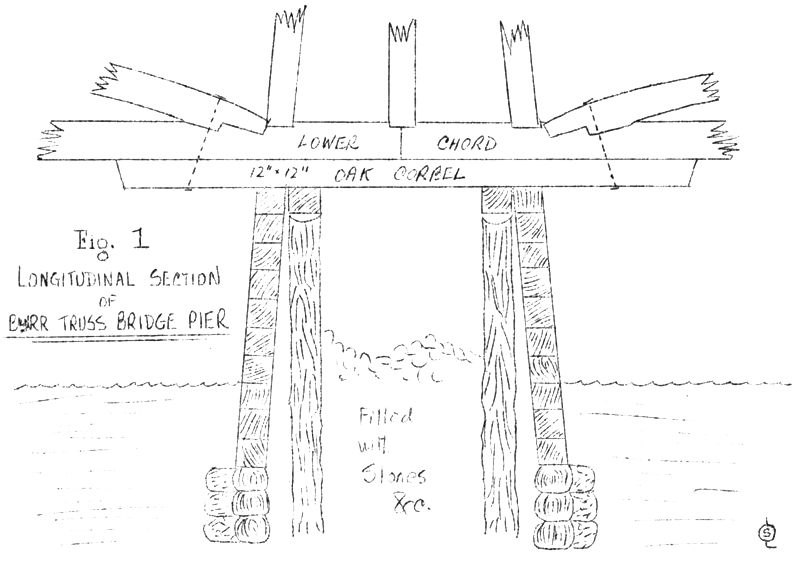
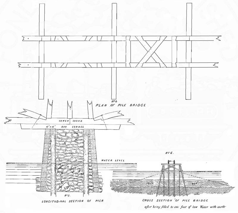
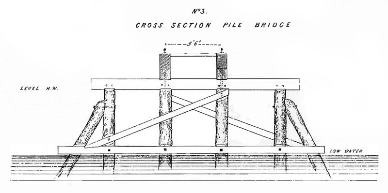
From Tic Island to the Trent Canal channel, the lake was deeper, averaging twenty-eight feet from low water mark. The channel is thirty-six feet from low water mark. This depth made a pile bridge impracticable, and the aforementioned truss bridge was substituted. The mode of construction was as follows:- Four long piles were driven and capped, to bear the vertical pressure of the bridge, until the cribs would sink to their bearings. They also served as guides for the cribs, which were built around them, 10x20' at the top, and battening 2" in 12" at the ends and 1" in 12" at the sides. They were made of square timber above, and round timber below, the water. They were sunk to their places through the ice in winter, and then loaded with boulders collected along the shore. (See accompanying diagram Figure 1).
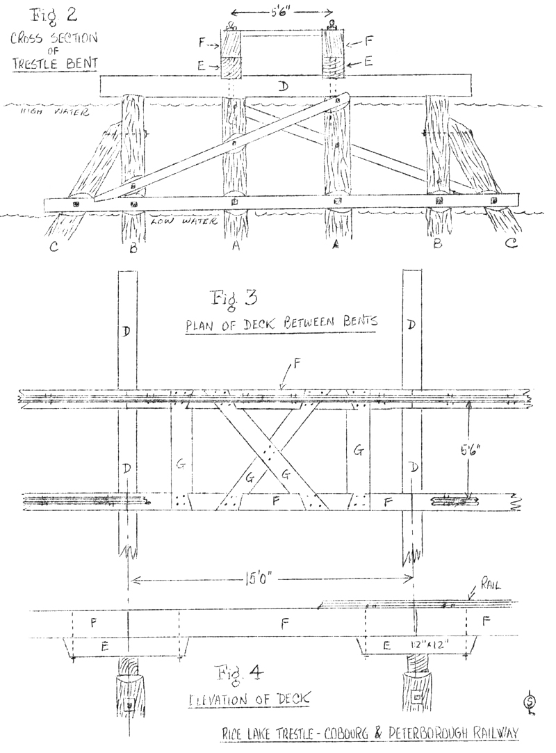
Inspection of the accompanying Figure 2 will demonstrate the supports for the trestle. The two center piles (A) were white oak, while the outer pair (B) and the spurs (C) wore in most cases pine or tamarac. These were driven and capped with pine caps 12x12".(D) The spur piles were driven with a leaning machine, so that their tops stood about four feet from the others. They were then drawn up with strong tackle and secured with 1" round bolts. The corbels (E) were fastened to the caps and piles by 1" square rag bolts three-and-a-half feet long. They were notched an inch on the caps. The stringers (F) of pine, 12x13" were secured to the corbels by 1" round screw bolts. Ties (G) of 3" oak
plank, connect the stringers on top. The total cost of the bridge had been "not far from $175,000".4
The bridge was constructed in the summer of 1853. After the next two or three winters, however, it was soon discovered that it was almost as difficult to maintain as it was to construct. In winter, the ice on Rice Lake formed to the thickness of two and one-half feet. After the ice had formed, the lake usually rose some two or three feet; and the ice, being frozen to the piles, would have the effect of a pile driver in reverse. Moreover, extreme changes of temperature in the winter season would cause the ice to buckle during the day, and then settle at night again.
In the first winter, that of 1853-54, the force of the rise in the level of the lake was sufficient to draw out a few piles near the Peterborough shore, and to raise the pile bridge north of the truss bridge some six or eight inches, except where it was held down by the cribs sunk every five hundred feet. Thus, it had a rather undulating surface and the contractors were obliged to raise and block up the stringers at these low points. It was proposed to prevent this raising of the ice by putting flash boards on the dam at Crook's Rapids, at the lower end of Rice Lake, and thereby raise it to maximum level before the ice formed. In order to maintain a constant water level in the lake, if more water flowed in, it would be drained off. On one occasion that winter, the ice cracked and broke the bridge. The result was that the two sections were out of line as much as 36 inches.
However, in common with most performances of a spectacular, and dramatic nature, the best was yet to come, for it was on January 1st, 1855, in the next winter, that the bridge received its worst blow to date. The day was warm, and the smoothness of the ice was marred by several ominous cracks. Because of these cracks, an ice jam began to form in the channel. This jam had the effect of pushing that ice which was not in the channel shoreward, taking the bridge with it. The north pile bridge was pushed toward the Peterborough shore, but owing to the number of cribs in it, it did not move too far. The truss bridge was pushed toward Tic Island, so much so that the span adjacent to the island slid four feet up on the solid abutment. South of Tic Island, the pile bridge was likewise pushed toward the Cobourg shore. It was pushed so far that the bridge parted near the island, leaving a gap of seven feet. The piles were now leaning at a crazy angle, and where the thrust met the resistance of the shore, it crushed the solid 12x18" stringers, turning them into splinters and bending the rails double. Mr. Clark then follows this description with the significant sentence: "This has all been since repaired, and the trains are now crossing
regularly."5
Since Mr. Clark's communication to the Canadian Journal is dated April 2nd, 1855, it becomes necessary to turn to other sources in order to ascertain the later history of the bridge. Unfortunately, these are scanty. We do not have ready access to local newspapers of the period, which might throw more light on the later story of the bridge. Professor Currie, in his book, The Grand Trunk Railway of Canada, (Toronto,1957) devotes three pages to the Cobourg & Peterborough Railway6, but he restricts his analysis mainly to financial and business details. What technical and engineering details he mentions are taken from sources which I have already investigated — from three Annual Reports extant, from the article of Mr. Clark, from J.M, and E.Trout, Railways of Canada, and the Statutes and Sessional Papers of the Legislative Assembly of" the Province of Canada.
From examination of the Trouts' Railways of Canada and Walling, H.F., Atlas of the Dominion of Canada, Montreal, George Nf. Tackabury, 1875), it appears that every winter the bridge suffered partial destruction. The prohibitive costs of repairing and maintaining the bridge were such, in 1857, as to force the road into bankruptcy. The bondholders foreclosed and in 1858 had an Act passed which enabled them, among other things, to take control. In January, I860, Messrs. Covert and Fowler leased the line and started to build a causeway in place of the bridge, according to the original plan. It appears, however, that in the winter of I860-61, the final blows were dealt to the improperly-built bridge by the ice.
In Mr. Walling's Atlas7, however, it is mentioned that the bridge was being reconstructed in a very substantial manner under the management of the Company's General Superintendent, and engineered by Walter Shanly; the bridge was to be reopened for traffic in l874. It is highly possible that that part of the embankment still in existence today8 (cf. map) dates from this attempt at reconstruction. However, it is problematical whether the bridge (or causeway, as it may now have become) was reopened. Evidence at hand indicates that the last year that the Cobourg & Peterborough Railway had full use of the Rice Lake bridge was in the year
1860.
Boldly planned but inadequately executed, the Rice Lake structure remains an important and ambitious part of the story of railways in Canada in pioneer times; it is one of the few natural obstacles which our early construction engineers, with their small engines and primitive equipment, were unable to conquer permanently and successfully.
EDITOR'S MOTE: Mr. Kenneth Heard, who assembled the notes foregoing, is engaged in writing a definitive history of the Midland Railway of Canada, its constituents and local
contemporaries. He would be interested in hearing from any reader who might have material, such as documents or photographs, to aid him in this research. Letters may be addressed to him in care of the Association,
BIBLIOGRAPHY:
1- Statutory History of the Steam & Electric Railways of Canada, 1336-1937, Robert Dorman,
2- Annual Report of the Cobourg & Peterborough Railway Company,
mentioned in Currie, A.W., the Grand Trunk Railway of Canada, (Toronto, Univ. of Toronto, 1957) p« 2S'4. 3T Clark, T.E. "On the Action of" the Ice upon the Bridge at Rice Lake1' in the Canadian Journal, June
1855, p. 249.
4- Constructional data on bridge from- Ibid., p.249
5- Ibid., p.250.
6- Currie, A.W., op.cit., pp.234-6.
7- Walling, H.F.: Atlas of the Dominion of Canada (Montreal, George
N. Tackabury, 18751, p .55.
8- Canada, Dept. of national Defense, Army Survey Establishment, topographical map, "Rice Lake", sheet 31 D/l East Half, scale 1:50,000, Second Edition, 1950.
The Sad Saga of Rice Lake.
from the Canadian Railroad historical Association news report
no. 334
by Fred Angus.
The network of Canada's railways covers almost every conceivable type of topography, from the level plains, to the mountain
passes of the Rockies. In the more than 140 years since the first railway ran in Canada, the development of this network has involved vast numbers of
engineering projects, among the most spectacular of which are the great bridges, which carry the rail lines over rivers, lakes and valleys. A
considerable number of these bridges date from the nineteenth century, although in many cases the original structure has been rebuilt to handle
heavier trains and increased traffic of the present day. Foremost among these nineteenth century bridges is the Victoria Bridge at Montreal,
constructed in the 1850's, rebuilt in the 1890's and still in use. While the construction of the Victoria Bridge is one of the great success
stories of mid-nineteenth century railway building, another, and even longer bridge, of the same period, offers an example of a spectacular
failure. This latter bridge, almost forgotten today, was 2.6 miles long, possibly the longest ever built in Canada, and almost double the length of
Victoria Bridge. This ill-fated structure was the Cobourg and Peterborough Railway bridge across Rice Lake.
In 1850 the aspect of Canada's transportation was just starting to enter its period of great change; the railway age. Until the late 1840's the
most dependable, albeit seasonal, was by water, and up until 1848 the Canadian and British governments had spent huge sums on a network of
canals in Canada. Although railways had been on the scene since 1836, the early lines were mostly intended to supplement existing waterways, and it
is only after 1848 that the value of the railway development got under way, the lines spread rapidly, and within ten years the Grand Trunk main line
was essentially completed and the transportation map of Canada was irrevocably altered by this new, fast system, which could operate in all seasons. Among the places adversely affected by the coming of the railway were the old towns, on both river and lake, which had once handled freight
shipments by water, and which now were threatened with being bypassed by the railways. One such town was Cobourg on Lake Ontario, which had once
shown promise of rivaling Toronto, and was even then in the process of erecting a large new city hall, which stands to this day. With the coming
of the railway, the citizens of Cobourg realized that they would lose much business, unless they too had a railway going inland from Cobourg, so making
their town the point at which goods and passengers could be transferred from the boats, and from the projected Grand Trunk, to a northbound
railway for travel to the interior. Thirty miles North of Cobourg lies Peterborough, and this was a logical initial destination for such a railway. Accordingly, in 1852,
an act of the Legislature of the Province of Canada was passed incorporating the Cobourg and Peterborough Railway Company, and
authorizing the construction of the line. The first sod was turned at Cobourg on February 9, 1853, the ceremony including a parade, ball, and
torch-light procession. The citizens of Cobourg celebrated this event, which was to bring even greater prosperity to their town in this era of
great progress. No doubt the line would soon have been completed to everyone‘s satisfaction had it not been for one great obstacle. Midway
between Cobourg and Peterborough lies Rice Lake, situated squarely in the path of the intended railway. Going around the lake would have unduly
lengthened the route, so it was decided to carry the track across the lake by means of a timber bridge, which would be one of the longest yet built in
the world! The lake is shallow, the bottom consisting of black mud in a semi-liquid state, which supported much growth of wild rice, but which
afforded no support to piles. Beneath the mud is a layer of hard, compact sand, and below that, clay. Even at the start there were dire predictions
from persons who knew the lake, that the planned bridge could not stand up to ice in the winter. However, expediency overruled reason and construction
began on the project of which a contemporary writer said, "A greater engineering or commercial blunder can scarcely be found in the Canada‘s". The contract for the construction was awarded to Samuel Zimmerman, contractor, builder and self-styled "railway king", whose death, in the Desjardins bridge collapse of 1857,
was one of the contributing factors of the depression which set in later in the decade.
The bridge crossed from the south side of Rice Lake to Tic Island, a distance of 3,754 feet. From there, for the next 2,760 feet there was a
series of wooden cribs 10 feet by 20 feet at 80 foot intervals filled with stone and carrying a superstructure of "Burr's truss" spans. At the channel was a
swing bridge giving two 50-foot passages when open. The remaining 6,728 feet to the north shore consisted of a pile bridge like the first, except
strengthened by crib work filled with stone. The entire bridge was 13,676 feet long, and required 184,000 feet of piling, 782,000 feet of timber, both square
and round, in the crib work, and 1,932,000 feet of square timber in the bridge itself. In addition the bridge trusses required 250,000 lbs. of iron
while, 20,000 cubic yards of stone were used in the cribs. Total cost was about $l75,000 which was a large sum for a structure on a short pioneer railway
of the 1850's. In the sections built on piles, the piles were driven with great difficulty into the hard sand. While it was intended to penetrate
through to the underlying clay, it was found so difficult to drive the piles (each blow drove it two inches at the most) that in most cases a
depth of ten feet into the sand was judged to be sufficient. In the centre of the lake the hard bottom is about 40 feet below high water, pile driving
to the clay was not even attempted, the stone in the cribs being deemed heavy enough to support the piers of the truss bridge. This judgment,
like the bridge itself was unsound, as was to be painfully apparent before very long. To be strictly fair to the promoters of the railway, the bridge was not intended to last
indefinitely, but only until sufficient fill could be dumped around it so as to convert it into a causeway. It would have been better if this had
been done at the start, however such a crossing might have been so costly that it would have killed the project at the outset, and by starting with
a bridge, the thought was that the fill could be placed over the next few years as revenue permitted.
Work on building the Cobourg and Peterborough continued during 1853 and 1854. During construction it became apparent that costs were greatly in
excess of estimates, and a dispute arose between the directors of the company and the contractor. A shortage of material and outbreaks of
sickness among the workers also complicated matters. Eventually the directors agreed to dispense with the services of Mr Zimmerman and
continue the work themselves. The Rice Lake bridge was completed in the summer of 1854, and the line pushed on towards Peterborough. Despite
difficulties with the bridge, the line was opened in December 1854 and amid much rejoicing, the inaugural train, hauled by locomotive "Cobourg",
newly built by James Good of Toronto, pulled the first train into Peterborough. The following year two additional locomotives, "Alma", named
after the recent battle in the Crimean War, and “Peterborough" joined the fleet. These locomotives were also built by James Good. In addition two
passenger cars, 82 freight cars, and five work cars completed the equipment. All were, of course of 5 ft. 6 in. gauge which was then the standard "Provincial gauge".
The line was scarcely opened when the ice began to play havoc with the new bridge. Ice two-and-a-half feet thick, formed on the lake, this tended to
buckle under the alternate heating of the bright sun and cooling of the cold nights. Furthermore, when the lake level rose the ice would lift too
and pull the bridge with it, pulling out the inadequately driven piles.
Although this effect had been noticed during the winter of 1853-54, at that time only part of the bridge was in place, but by 1854 the total
effect was much worse, with the entire bridge subject to the moving of the ice. The worst damage was caused on January 1, 1855 when a massive shove
moved two parts of the bridge in opposite directions, creating a seven foot gap. This of course stopped operations, but was eventually repaired
and the spring of 1855 saw the bridge still in service but twisted and shaken and pushed out of line in many places. There is no record of the
speeds of trains on the structure, but they must have been VERY slow. It takes some imagination to picture the scene of a 4-4-0 wood-burning
locomotive hauling two light wooden passenger cars over the undulating twisting line. The creaking, pitching and swaying must have been
incredible enough to cause seasickness in the most experienced sailor.
By the start of 1856 the total cost of the line was almost a million dollars, and revenue was not sufficient to pay, even the working expenses and bond
interest, as money was being constantly spent to keep the bridge in repair. In 1867 the line was leased to a mister D. E. Boulton who appeared to
be somewhat more successful in management. However just at this time, the Port Hope, Lindsay and Beaverton Railway obtained authority to build a
branch line to Peterborough from Millbrook on their main line. This branch was opened on August 18, 1858, was only three miles long, and was more
dependable than the Cobourg and Peterborough. As a result the latter‘s traffic fell so much that the bond-holders foreclosed on the line in the
same year, and through-service was discontinued. However, one last attempt was made, in 1860, to revive the line and replace the bridge with an
embankment, this was also unsuccessful, and finally, in 1861, the ice completed its destruction and the bridge was swept away, never to be rebuilt. So ended
the through railway from Cobourg to Peterborough, and for some years the only connection to Peterborough was by way of Port Hope.
However the whole story was not quite ended. In 1865, what was left of the railway was sold for $100,000, and the following year it was amalgamated
with the Marmara Iron Works, to form the Cobourg Peterborough and Marmara Railway and Mining Company. By 1870 total trackage was 25.5 miles including
a physically-separate branch to Blairtan, the site of considerable mining operations. In the 1870's most other railways which had been 5 ft. 6 in.
gauge converted to standard 4 ft. 8.5 in., however the C P and M could not afford to make the change. By the mid eighties it and the Carillon and Grenville were the only broad gauge lines left in Canada, and this
situation continued until 1889, when the former Cobourg and Peterborough lines were abandoned. As the railway was 5 ft. 6 in. gauge to the end, it is likely that the original locomotives survived until then when they were no doubt scrapped having served for 35 years.
So ended the story of a railway which had been conceived with such optimism and which proved such a disappointment. It is difficult to tell what might have happened if circumstances had permitted the building of a more substantial bridge across Rice Lake. Would this now have been a main connecting link in one of Canada's major railway systems and would Cobourg
have become a large railway junction, or would the line have suffered the fate of so many other branch lines in the later twentieth century? This is difficult or impossible to say, but it is true that the Cobourg and Peterborough achieved three distinctions;
it built the longest railway bridge in Canada. Portions of the line were among the first to be abandoned in Canada. The remaining part of the line became the "second-to-last broad gauge". Although the project failed to
achieve its objective, the construction of such a long bridge was a good example of the spirit of the railway pioneers, a spirit which in so many other cases pushed railway lines on to success and helped to build the network which helped to bind together the nation.
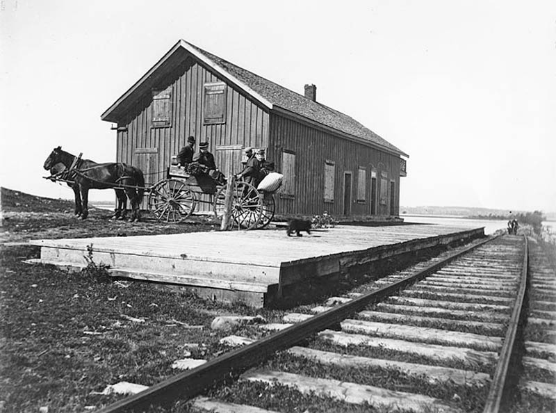
Harwood Station on the Cobourg and Peterborough Railway, as seen looking from the
south to the north-northwest. On the right the rails run out onto the
causeway that formed the first part of the bridge across Rice Lake. Tic
Island, where the bridge proper started, can be seen in the distance. The
causeway as seen in this image appears to be in bad repair, which suggests
the photo was taken some time between 1861 when the bridge collapsed, and
WWI when the rails were lifted and sent to Europe. The station appears to
be abandoned, which suggests it was later during this span of time.
- c1900
Use the form below to comment on this article. A name is required, an email address is optional, Email addresses will not be revealed.